
MCNY Blog: New York Stories
Iconic photos of a changing city, and commentary on our Collections & Exhibitions from the crew at MCNY.org
What lies beneath New York- the Minetta Brook
It is difficult to view this image of Manhattan from 1953 and imagine it as the idyllic island of Mannahatta that Henry Hudson first stepped onto in September 1609, but at one time all of the built environment we see was lush, green, and full of streams and natural waterways abundant with fish.

Aerial View of Manhattan. Fairchild Aerial Surveys, Inc. 1953. Museum of the City of New York. X2012.11.13057
There are a few daily reminders of this in our street names. Canal Street lies above what was once an actual canal, built to drain the Collect Pond, a large body of water that used to exist on the southern tip of Manhattan Island. Spring Street is named after a spring that flowed into Lipsenard’s Meadow, a swampy area near Canal Street. While many of these waterways no longer remain, there are a few that still exist, unseen and hidden, but flowing beneath our feet. One of the most interesting of these underground waterways is the Minetta Brook. Minetta’s flow is evidenced in street names such as Minetta Lane and Minetta Street, and the Minetta Triangle at 6th Avenue and Bleecker Street.
Minetta Brook , originally “Bestavaar’s Kill,” was once “a brisk little affair, hurrying along in its well-defined channel, apparently as full of business as it was full of trout. Yes, of trout! They were there in abundance, darting to the higher waters like streaks of smoke and flame, against the foamy rush of a narrow channel, or sulking under the shadow of the bank in quiet pool below….” (Old Wells and Water-Courses of the Island of Manhattan, by George Everett Hill and George E. Waring, Jr, 1897)
The original path, which it still follows underground, began with two spring-fed forks, one starting at Fifth Avenue and 20th Street and the other starting at Sixth Avenue and 17th Street. They merged in the vicinity of 11th street and Fifth Avenue, continued southwest through Washington Square Park, and joined the Hudson River between West Houston and Charlton Street. This map from 1852 and the accompanying cropped detail clearly show Minetta Brook, Bestavaar’s Kill at the time, with long-vanished surrounding farm plots.

Map of the City of New York showing original high water line and the location of the different Farms and Estates. D.T. Valentine and George Hayward. Ca. 1852. Museum of the City of New York X2011.5.184
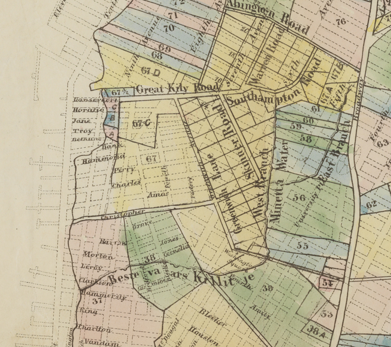
Detail of map of the City of New York showing original high water line and the location of the different Farms and Estates. D.T. Valentine and George Hayward. Ca. 1852. Museum of the City of New York X2011.5.184
Here is a later map from 1874 depicting a more topographic view of Manhattan, including original water routes and swamps overlaid with the constructed grid plan and expanded waterfront. The current path of the Minetta Brook beneath the city streets is clearly shown.

Topographical Atlas of the City of New York Including the Annexed Territory. Showing original water courses and made land. Ca. 1874. Egbert L. Viele. Museum of The City of New York. 37.296.1A
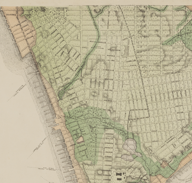
Detail of Topographical Atlas of the City of New York Including the Annexed Territory. Showing original water courses and made land. Ca. 1874. Egbert L. Viele. Museum of The City of New York. 37.296.1A

Richmond HIl House or Theater. Louis Oram. 1870. Museum of The City of New York. 29.100.1661
The area where the Minetta Brook joins the Hudson River, in the vicinity of present day Varick and Charlton Streets, was once a colonial estate called Richmond Hill where Major Abraham Mortier, paymaster of the British army at the time, constructed a mansion in 1769. Mortier’s estate was most famously used as headquarters by George Washington and Lord Amherst, Commander and Chief of the British Forces during the French and Indian War. Richmond Hill House would go on to have many more renowned residents such as John Adams and Aaron Burr. In 1831 it was converted to a theater. It was torn down in 1849.
By the 19th century, the area along the Minetta Brook had come to be known as “Little Africa,” due the large numbers of African Americans who had settled there. This pattern dated back to the 1640s when recently freed slaves received land grants along the shores of the brook, which was at that time on the outskirts of New Amsterdam.

Reflection- Washington Square. Fredrick Kelly. August 29, 1960. Museum of the City of New York. 2001.59.20.
Diverting the path of Minetta Brook and laying the city streets over its banks was no small feat. Washington Square Park was once a swamp fed by the brook. To build the park, the city had to drain the land and reroute the brook. Much of the area around New York University and the West Village would still be on the banks of Minetta Brook had the city not channeled its flow into culverts and sewer tunnels. Most of the streets around the area run parallel to the original path of Minetta because they were laid out with the waterway in mind.
It’s hard to imagine the natural environment still affecting lives in one of the most urban locations in the United States, but the brook does indeed still flow underground, fed by natural sources. To this day, construction crews working in Minetta’s path have to be careful not to unearth it when digging. Many basements in the area have a tendency to flood after a particularly heavy rain. The NYU Law School Library fights a constant battle against Minetta’s underground spring. Located at the south‐west corner of Washington Square Park, there is a continuous flow of groundwater into its basement at an estimated rate of 2‐5 gallons per minute in dry weather, which is pumped into a nearby sewer (more information here). Sink holes are also a common occurrence along 12th Street in the area where the two forks of Minetta converge.
I was recently fortunate enough to take a walking tour of Minetta’s path led by urban historian and photographer Steve Duncan. He led us from the area around Union Square through Washington Square Park to the Hudson River, popping open manhole covers and revealing the rushing waters of Minetta. More information about Steve and this incredibly informative tour can be found here.

Minetta Place. Arthur D. Chapman. 1914. Museum of the City of New York. 51.130.5
Today the area surrounding Minetta Lane is lively and full of bars, restaurants, shops and, most importantly, is completely swamp free thanks to the efforts to submerge Minetta’s flow. The natural spring water is now mixed with sewage and carried out to the Newtown Creek sewage treatment plant in Brooklyn.

Minetta Lane. Glenn O. Coleman. 1928. Museum of the City of New York. 54.405.1
4 comments on “What lies beneath New York- the Minetta Brook”
Leave a comment
Museum of the City of New York


I will think on this next time I am in the neighborhood! Reminds me of Providence, RI which had long covered over its own river at the center of town. However, in recent years the river has been re-opened and it is now the center of public activities. Above or below ground, they can’t be ignored! Thanks for a great story.
Pingback: Tuesday’s preservation news | Charles Starks, Urbanist
Pingback: What Lies Beneath: The history of Minetta Brook—whose dregs… – insiderater.com
Pingback: On the Market: Even Stockholm Has Affordable Housing Problems; REBNY PAC Goes Negative; The Story of Minetta Brook – insiderater.com